Twareg desert footprints
Twareg desert footprints tour
Day 1 : Sebha – Wadi Methkendoush – Ubari
Highlights: Wadi Methkendoush and the landscape.
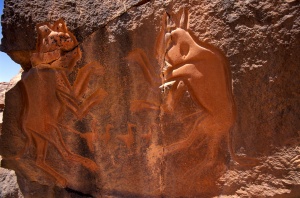
From Sebha airport we will Board our 4×4 Jeeps and drive to the first sight Wadi Methkendoush. Wadi Methkandoush lies along the southern side of the Msak Settafet. It has one of the richest concentrations of prehistoric rock carvings in the world. Most of the carvings in the soft sandstone date back at least 12,000 years, making this one of the oldest rock art sites in North Africa.
Day 2 : Germa – Akakus
Highlights: Germa, Acacus and theLandscape.
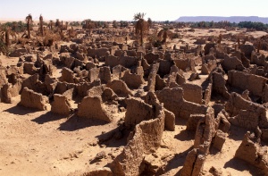
Departure by 4×4 Jeeps to the site of Germa and visit of the site. The Garamentes, legendary and mysterious population of the Libyan Sahara founded the oasis town of Germa. They were famous for their travelling through the Fezzan Wadi on their horse drawn carts, for the ploughing of the land and for riding oxen with giant horns. One thing we know for sure is that the Garamentes were Roman enemies and probably the allies of the Carthaginians. They controlled the desert caravan trade from Ghadames south to the Niger River, eastward to Egypt and west to Mauritania. Their wealth and technical skill are also attested to by the remains of their towns, which were built of stone and more than 50,000 of their pyramidal tombs. Drive to the south west. Our drive will take us through mountainous landscapes alternated with sand and stones, announcing slowly the arrival at the Acacus.
Days 3 & 4 Acacus
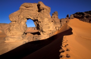
Highlights: Big arche and the Acacus landscape.
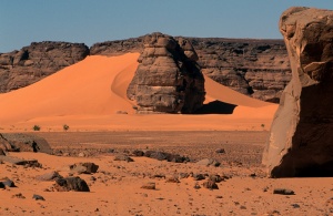
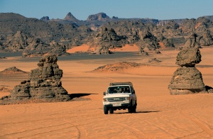
Two full days will be spent in the magical Acacus desert. The Acacus is a vast Rupestre Museum situated in the mountainous region east of Ghat. It is ploughed with a great number of wadi ( dried beds of the prehistoric waterways ). The valleys whose rocks are formed by ancient sands, divide themselves into various plateaus of various heights. On the east side a steep slope formed of scattered rocks, headlands pathways and turrets which barely rise from the rubble and debris. The biggest wadi on the exit of the Tadrat is named Takhisset, the mass of sand dunes forces its path north between the Erg and the Akakus where it consequently takes on the names of Ouan Eillel, Ouan Kassa and Taita.
Day 5 : Akakus – al Aweinat – Ubari Lakes
Highlights: al Aweinat, Ubari lakes and the landscape.
Departure to the Northern oasis of Al Aweinat. At one time it is thought that Al Aweinat was an ancient qasr left to ruin, the French explorer Duveyrier attributed its construction to the Garamentes. A lost oasis with an only great tree in the middle where a water spring of considerable volume rises from a basin of approx 4 mtrs long x 1.5 meters wide. The then smaller water canals flowed to irrigate the crops of cereals grown at that time. Hence the reason why the Arabs called this place Al Aweinat (the springs).
Day 6 : Ubari lakes – Sebha
Highlights: Ubari lakes and the Landscape.
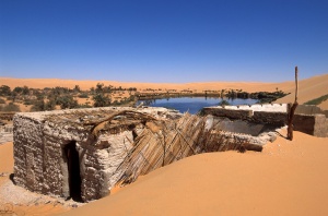
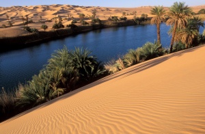
Full day dedicated to the visit of the salt lakes. South-east of the Ubari Erg, north of the valley of Wadi Adjal is Dauada, the region which contains a series of lakes situated in the middle of sand dunes surrounded by palm trees. There are approximately 21 lakes spread out over this region. The most famous lakes are found in the south Mandara, Um el ma, Gaberon and Mafo with Um el Hassan being the biggest lake found here. Ummelma Lake is the most suggestive, due to the iridescent colour of its water. This lake is small and narrow. One can partially walk near the coast till reaching a small beach surrounded by vegetation. The lake and the ancient village of Gaberoun are situated at an altitude of 400m. The Gaberoun lake originally known as`Bahr ed Doud ( sea of worms ), is found north of the village of Bendbeiya at approx 41km into the Erg.
A small abandoned village of a Libyan black community lived there until the early eighties until modern life obliged the authorities to move the village to a new modern village built exclusively for them. This population used the worms living in the lake as their main source of food. Mafo lake is located approximately 400 m below sea level. It has a circular shape and is small and very suggestive. Its water, which never exceeds 7m depth, has the same characteristics of Gabron: a high level of various kinds of salt, probably due to its natural position and location.
-
IncludedAccommodations/Wild campingTransport.Food.Drinks.Private Guide ENG speaking.
-
Not IncludedInsurance.
